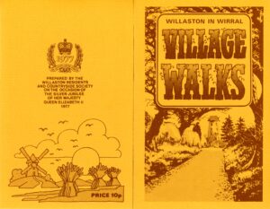
Willaston Walks
Willaston has many delightful footpaths and we have developed some local walks for residents’ and visitors’ enjoyment. These were initially developed in 1977 to celebrate the HM Queen Elizabeth’s Silver Jubilee.
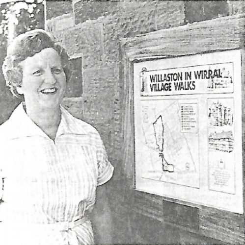
Mary Daugherty, Chairman of WR&CS in 1977, was largely responsible for the map of village walks (photo: Cheshire Life)
During 2015, thanks to funding from Merseyside and West Cheshire Ramblers, we purchased new way mark posts for the walks and a dedicated team of volunteers helped erect them.
Below is a map and description of the walks in and around Willaston. Stout footwear is recommended for all walks.
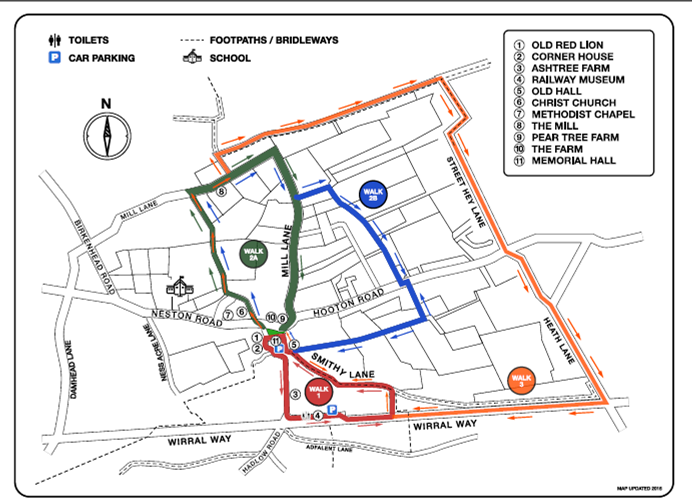
WALK 1 (1.1 mile/1.8 km)
Before leaving the Green, notice the copper beech tree which was planted in 1935 to commemorate the Silver Jubilee of King George V.
The half-timbered house to your right, which for part of its life was the Red Lion public house, has been thoroughly renovated. It is likely that the date of 1631 on the house plate marks the year when the original building was enlarged or substantially improved by John Bennett.
Along the lane at the side of the Memorial Hall you pass White House farm and Corner House Farm, now the Pollard Inn on your right. While the brick wing of the Inn appears to be 18th century work, the stone wing may be the oldest such fabric remaining in the village.
Bear left around the Memorial Hall. Then turn left and immediate right along Hadlow Road – the name is probably taken from the Domesday manor of Edelaue.
You soon reach the attractive Ash Tree Farm, once the home of the Wilsons, who were related to the famous bishop of Sodor and Man; its timber-framed wing is thought to date from the 16th century or earlier; the brick and stone wing bears the date 1697.
Continuing along the road, you pass, opposite the garage the 19th century Rose Farm and the adjoining Rose Cottage. When you reach the Wirral Way, go inside the former railway station, which is furnished as it might have appeared shortly before the line’s closure to passenger traffic in 1956, 90 years after it was opened.
Follow the Wirral Way for 300yds/275m ignoring the first cross path, then left up the steps and bank, following the footpath into Smithy Lane; where you turn left. The lane is so called from one of the village’s two smithies, the site of which you pass as you regain Hadlow Road. Turn right.
Behind the wall as you return to the Green is the Old Hall, handsomely built in brick and stone in the Elizabethan style, but thought, despite the date over the entrance, to have been built in the mid 17thcentury.
WALK 2a (1.3 miles/2.1 km)
At the North West corner of the Green, Laburnum House, formerly a farm, which although much altered, dates from the 18th century. So does the building opposite, standing back from the street; it was for some years the Green Lantern café. Turn left and use the pedestrian crossing.
As you take the path beside the church-yard, reflect that Willaston was served by the parish church of Neston until Christ Church was built in 1855; in fact not until 1865 was the village made a separate parish. (The Methodist chapel along the road, dating from 1889, replaced one erected near the Green in 1838.)
When you reach the houses of Elm Road, cross diagonally to the left to a narrow opening to a path that will lead you to the recreation ground. Keep the hedge to your right, pass Jackson’s pond and the Big Meadow and through the field beyond. (You might like to rest a while by the pond or in the meadow). When you reach Mill Lane, turn right. Wirral’s largest flourmill was built in 1800, and was used until about 1930. There was probably a mill near this site since the 14th century; it would have been the “post” type, the design depicted on an estate map of 1774#.
As you walk down towards the bend of the lane, you may see to your left across the fields the tops of Liverpool’s two cathedrals. Further on you reach substantial houses*. Most of these were built in the 1920s, surrounded by mature gardens and trees. At the junction with the main road, the 18th century origin of the Nag’s Head public house is more easily discerned from the side than from the drastically altered front; once the White Horse, its house-plate has the date 1733.
Before crossing Hooton Road to return to the Green, you will see on your right the single storey cottage with gabled dormer, and its neighbour, which now houses ‘White Feather Home’ but was once Pear Tree Farm, both belonging to the 18th century. The Farm, dating from the 17th century, is now several private houses; it was a farmhouse until 1912. Notice the pitching eyes in the brick barn at the rear.
WALK 2b (2.1 miles/3.4 km)
Follow the route description of walk 2a until *. Turn left down the footpath immediately before the first large house. This footpath was known as Accors lane when the tithe map was drawn in 1848. The footpath turns right and later narrows before reaching the Hooton Road. Cross diagonally left across the road and walk down Change Lane until you see a footpath crossing the fields on your right. (It is believed that there was a Coaching Inn at the end of the lane and the change horses for the coaches were grazed on the field where Change Hey now stands.) Follow this path straight through three fields and emerge onto Pemberton Close. Walk straight ahead until you reach Moss Close. Turn right along Moss Close and immediate left up Old Vicarage Road. Just before you reach some bollards, you will see a footpath to your right. Follow this path. It will take you past the Old Hall with its stone mullioned and transomed windows as you return to the Green.
WALK 3 (3.7 miles/6 km)
This extension of Walk 2a makes use of the Wirral Way. Follow walk 2a until you pass the mill on your right at #. Shortly after this you turn left following the sign to Raby. After 180 yards (150m) you will see a waymark sign on your right. Follow this path through four fields before you reach a bridleway. After turning right here you will eventually join up with Street Hey Lane. Walk along this lane, cross over the Hooton Road and walk along Heath Lane, which follows a Roman Road. Bear right before the bridge. Then turn right onto the Wirral Way and continue until you meet Walk 1. N.B. Ignore the first steps to your right. Turn right up the steps and bank. Follow route 1 description from % back to the Green.
WW1 commemorative walk
In 2018, we also have developed a historical walk of Willaston in recognition of the 100th anniversary of the First World War. This tell you about the village in 1918 and some of the men who lost their lives. For a copy, click here: WW1 walk
Coronation Walk
In 2023, a further walk was developed to mark the Coronation of Charles III, which includes a picture quiz. A copy is available here: Coronation Walk.
The quiz with answers is available here: Coronation Walk Answer Sheet
Willaston has many delightful footpaths and we have developed some local walks for residents’ and visitors’ enjoyment. These were initially developed in 1977 to celebrate the HM Queen Elizabeth’s Silver Jubilee.